Trail Walking Santa Maria Maior - Lisbonne J1 - Photo
 JimBlues
JimBlues

User

© OpenStreetMap contributors
Length
Length
4.8 km
Max alt
Max alt
87 m
Uphill gradient
Uphill gradient
128 m
Km-Effort
Km-Effort  
6.4 km
Min alt
Min alt
0 m
Downhill gradient
Downhill gradient
104 m
Boucle
Boucle
No
Creation date :
2022-09-20 07:14:53.649
Updated on :
2022-09-20 07:23:30.044

(0 Reviews)

Walking
Walking
1h27
Difficulty : Medium

Scan this QR Code to open this trail in the SityTrail application

FREE GPS app for hiking

Logo SityTrail SityTrail

IGN / Geographical institutes

Download SityTrail from the App Store Download SityTrail from Google Play

Logo SityTrail SityTrail Plus

The world is yours!

Download SityTrail from the App Store Download SityTrail from Google Play Download SityTrail on Huawei AppGallery

About

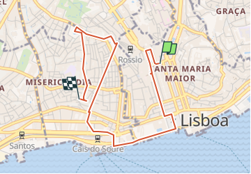
Trail Walking of 4.8 km to be discovered at Área Metropolitana de Lisboa, Lisbon, Santa Maria Maior. This trail is proposed by JimBlues.

Elevation profile

Points of interest

Point of interest Misericórdia - Resto Me Petisca - Photo
JimBlues
MISERICÓRDIA 
Point of interest Misericórdia - Mercado Ribeira - Photo
JimBlues
MISERICÓRDIA 
Point of interest Santa Maria Maior - Elevador - Photo
JimBlues
SANTA MARIA MAIOR 

Positioning

Country:
Portugal
Region :
Área Metropolitana de Lisboa
Department/Province :
Lisbon
Municipality :
Santa Maria Maior
Location:
Unknown
Start:(UTM)
487982 ; 4284954 (29S) N.


Close
My subscriptions